Getting Started with SA Climate Ready
Note: It is recommended that you read the Data User Guide to gain an understanding of the data available for download, and how to work with it.

-
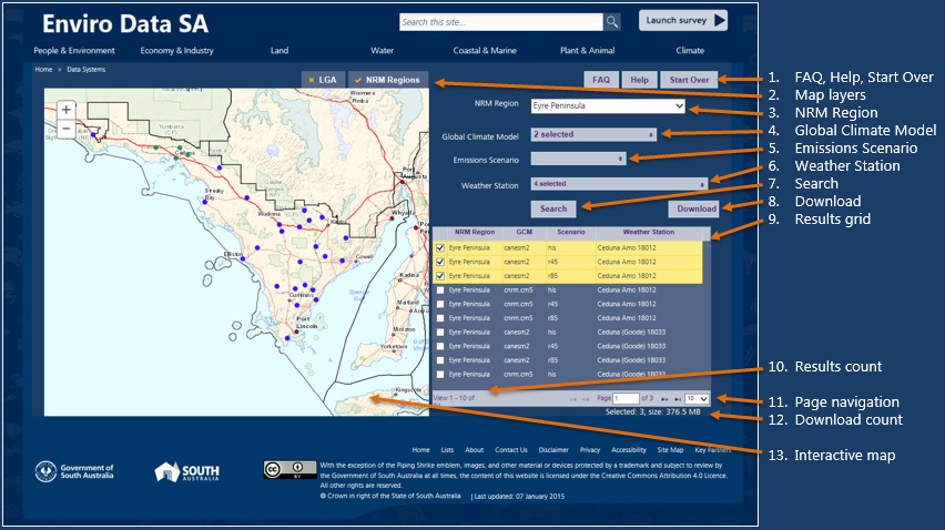
FAQ: View the Frequently Ask Questions page about SA Climate Change Ready.
Help: View this page.Start Over: Clear the search criteria and start again.
Map layers: Show/hide boundaries on the map for NRM Regions (Natural Resource Management) and/or LGA (Local Government Authorities). The NRM Region boundaries map layer is shown by default. As you mouse over an NRM region it is highlighted with a coloured fill.
NRM Region: You must select an NRM Region on which to base the search.
Global Climate Model: Filter the search by selected models, or leave blank for all models. Leave blank to include all models. The best 6 models are appended by an asterisk (*). See the
Data User Guide for information about the models listed.
Emissions Scenario: Filter the search by selected scenarios, or leave blank for all scenarios. See the
Data User Guide for information about the models listed.
Weather Station: Filter the search by selected weather station(s), or leave blank for all weather stations. You can also select weather stations from the map, as described below.
Search: Click to submit the search criteria. The results are shown in the grid below.
Download: Enabled only when you have selected items from the results grid (below). Click to submit your download request. You will be asked to accept the data terms & conditions, and for an email address to which we send a notification when your download is ready for retrieval. Once the notification email is sent, your email address is removed from our system. We do not store the email address for any other purpose.
- Results grid: Shows the results of the search at 10 items per page. You can:
- select individual items for download by clicking the corresponding checkbox.
- select all items on the page by clicking the checkbox in heading row.
- change the sort order by clicking the column headings.
- navigate between pages of results (see Page navigation below).
change the number of results on the page (see Page navigation below).
Results count: Shows the total number of search results found and the range displayed on the current page.
Page navigation: Navigate between the pages of results. You can select to view 10, 20, 30 or 100 results per page. Any selections made on previous pages are retained.
- Download count: Accumulated count of the number of items selected for download, and the accumulated data file size. A limit of 2 GB applies. As you select the data you want, the accumulated size of the relevant data files is calculated. If this exceeds the limit, a message appears telling this. In which case, you have two options
Select and submit multiple download requests, each within the limit; or
Visit the
CSIRO Data Access Portal to perform a bulk download, e.g. download data for an entire NRM region or the state.
- Interactive map: The map provides the familiar zoom and pan features, including:
- Mouse actions for panning (click and drag) and zooming (mouse wheel).
- Zoom slider: Click + or – to zoom in or out respectively.
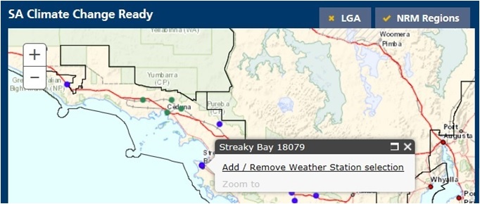
- Click a dot to see a popup box showing the name and identification number of the corresponding weather station, as shown in the image below.
- In the popup box, add or remove the weather station to/from your selections by clicking the Add / Remove Weather Station selection. The Weather Station filter is updated accordingly, including the number of selections.

If you need assistance with data downloads and/or interpreting the data, please submit a request via the
Contact Us page.