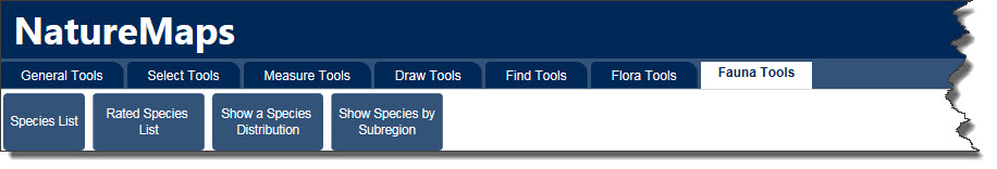
An update to the toolbar interface in NatureMaps has been released. The "I Want to ..." menu and compact toolbar, when using a PC or Tablet, has been replaced by a tabbed toolbar format, whereby all tools will be accessible from grouped tabs.
Based on feedback received, and the increased tools and functionality now available in NatureMaps, there will some improvements to the way tools are accessed. The "I Want to ..." menu and compact toolbar, when using a PC or Tablet, will be replaced by a tabbed toolbar format, whereby all tools will be accessible from grouped tabs.
Here you will find all the 'General' tools you will use in NatureMaps, such as Printing, Querying and Data Upload Tools.
Here you will find all the selection/identify tools which allows you to select and return information about features in NatureMaps.
All measurement tools are now available under one tab. This will make swapping between, and editing, the different measurement options much simpler and easier.
All the drawing, style, editing and export tools are now available under one tab. This will make swapping between, and editing, the different drawing options much simpler and easier.
July 2016
08/07/2016
Changes to the 'I want to …' Menu
The Flora and Fauna tasks have now been consolidated under two headings.
Query Flora Data –
Generate and download a unique species list from the Flora Supertable (BDBSA) layer for an area of interest.
Area of interest can be a
Note: there are some restrictions on the size of a manually defined area of interest because of possible performance issues
Generate and download a unique species list of both nationally and state rated species for a manually defined area of interest (rectangle/polygon/current extent)
Display the distribution of a selected species or genus in South Australia from the Flora Supertable (BDBSA) layer
Show where a species has a conservation rating at subregional level in South Australia. From the 'Subregional Species Status' layer under Fauna and Flora. See the metadata link for the layer for more details on the data.
Query Fauna Data –
Generate and download a unique species list from the Fauna Supertable (BDBSA) layer for an area of interest.
Area of interest can be a
Note: there are some restrictions on the size of a manually defined area of interest because of possible performance issues
Generate and download a unique species list of both nationally and state rated species for a manually defined area of interest (rectangle/polygon/current extent)
Display the distribution of a selected species or genus in South Australia from the Fauna Supertable (BDBSA) layer
Show where a species has a conservation rating at subregional level in South Australia. From the 'Subregional Species Status' layer under Fauna and Flora. See the metadata link for the layer for more details on the data.
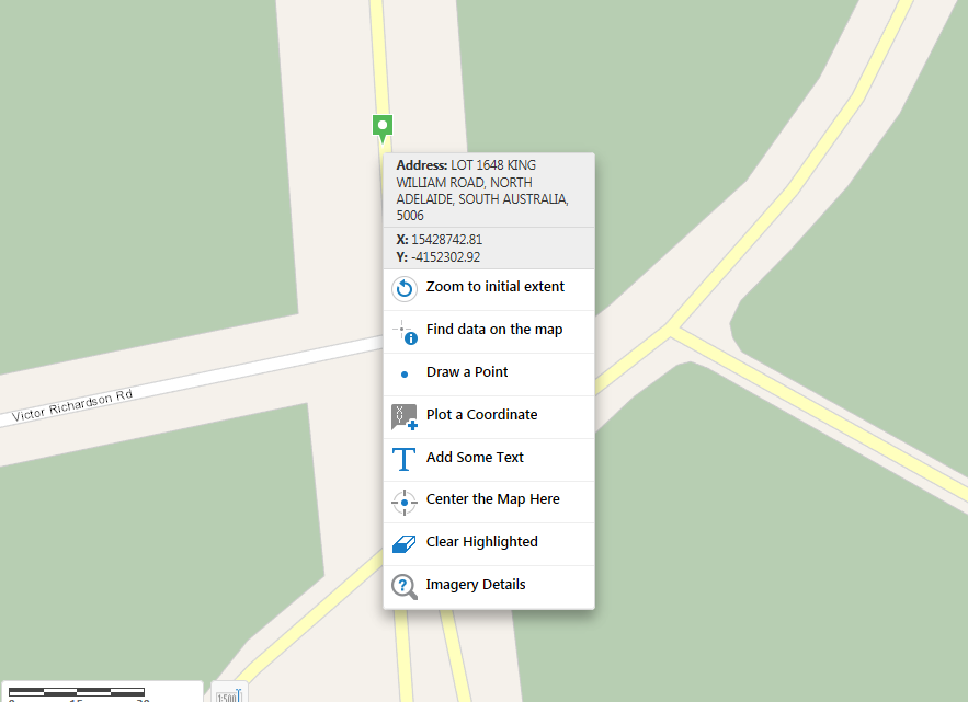
Plot a Coordinate
The Plot Coordinates Module allows you to show the coordinates for specific locations on the map. To show the coordinates for a particular location, either select the location on the map or input coordinates using text boxes in the Plot Coordinates panel.
Plotted coordinates can be printed or exported as a csv or xlsx.
Add Data to Map
Allows you to upload data in the following file types from your computer, and view them on the map:
.csv, .xlsx, .kml, .shp, .gpx, or a .zip file containing a .shp
This tool replaces the Load a CSV File and Load a GPX File tools
Open Google StreetView
This tool opens up an interactive linked view between NatureMaps and Google Street View
New Layer Actions
From the Layer Actions Menu, you can now directly access the Metadata and, where available, the data download link for that layer.
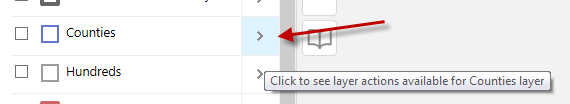
This replaces Data Downloads and Metadata pages on the NatureMaps website.
Right Click Context Menu
The Right Click Menu has undergone some enhancements.
When using the right mouse button, or long press on a tablet, you can retrieve address and coordinate information for that location.
By clicking on the Imagery Details option, you can also view (where available) imagery details information at that location
Export Drawings to Shapefile
A new export drawing (markup) to shapefile tool has been added to the toolbar ribbon. The Export Drawings tool extracts the markup layer and creates an Export.zip file containing all of the drawings. This feature is enabled only after markup has been added to the map.
If the Edit Drawings tool is enabled, the Export Drawings tool will be disabled.
When the Export Drawings tool is selected, a confirmation dialog will appear. Once accepted, the Export.zip file is saved to your device.
Please note: Measurement markup exported to shapefile does not include the measurement details (eg length, area, angle or bearing)
Similarly, exports do not include text or drawing styles from the markup layer.
Save Results Feature
The Saved Results feature, allows you to save, open and modify collections of features. After performing a search, query or identify operation, you can save the results with a name that appears in the title of the results panel when the saved results are viewed. You can rename or delete saved results.
You can only open one set of saved results at a time. You can add or remove features either through the Panel Actions Menu while viewing feature details, or via a link in a feature's map tip. You can also modify the current results by using the Combine Results option to either: add saved results, subtract saved results, or match intersecting saved results. Saved results that have unsaved changes are marked with an asterisk (*) at the end of the panel title.
Note: Saved Results only persist for the duration of your browser session. If you refresh or close the browser, you will lose all Saved Results.
March 2016
10/03/2016
In this update there have been a number of layer name and content changes, please see details below
Layer name changes
|
Old Layer Name |
New Layer Name |
Flora Sites - Biol Survey SA | Flora Site Locations |
Fauna Sites - Biol Survey SA | Fauna Site Locations |
State Rated Fauna Sites (Denatured) | State Rated Fauna Sites |
Nationally Rated Fauna Sites (Denatured) | Nationally Rated Fauna Sites |
State Rated Flora Sites (Denatured) | State Rated Flora Sites |
Nationally Rated Flora Sites (Denatured) | Nationally Rated Flora Sites |
New Layers:
Under
Fauna and Flora folder
Flora Supertable (BDBSA)
Fauna Supertable (BDBSA)
Phytophthora Records
Deleted Layers:
The following layer(s) have been removed from NatureMaps
Folder Changes:
The Soils folder has been moved out of the Landscapes folder and now sits out directly under the Table of Contetnts (TOC). There has also been some reordering of the layers within the Soils Folder.
I want to ... menu changes:
There has been some names changes to some of the tools in the
I want to ... menu. Please note that the tools still operate the same, they have been renamed to be more appropriate.
|
Old Tool Name |
New Tool Name |
Show Rated Flora Species | Show National and State Rated Flora species |
Show Rated Fauna Species | Show National and State Rated Fauna species |
Show Regional Status for Fauna Species | Show regional ratings for fauna species |
Show Regional Status for Flora Species | Show regional ratings for flora species |
The following tool(s) are out of date and have been removed.
9/03/2016
There may be some service interruptions to NatureMaps between 5:30pm and 6:30pm on Thursday 10th March, due to data content updates
November 2015
19/11/2015
NatureMaps has been updated to included a number of new tools. Tips on how to use these tools will follow shortly.
Available from the
I Want To ... menu:
- Zoom to Coordinates
- Load CSV file
Extra functionality has also been added to existing tools:
Identify Tool
- Set a Buffer Distance when identifying an object.
- Enable/Disable layers selected for indentifying operations
- Identify features within a selected buffer distance of an identified feature.
Draw Tool (available for Line and Polygon draw tools)
- Snap to existing feature when drawing
- Select which layers are snappable
Measure Tool (available for Line and Polygon measure tools)
- Snap to existing feature when measuring
- Select which layers are snappable
September 2015
4/09/2015
Bushland Condition Sites added to Flora and Fauna theme.
Sanctuaries added to Protected Areas|Land|Areas Providing Protection.
August 2015
28/8/2015
Over the weekend of the 29th & 30th August 2015, the Topographic Overlay will undergo some changes.
The Topographic Overlay has been simplified in an effort to improve the print quality when used in conjunction with the Aerial Imagery base map.
The labelling and symbology of the road layers have been adjusted, and a number of layers removed.
Several of the layers removed are available as individual layers in the Layer List. If required, you can turn on these individual layers in conjunction with the simplified Topographic Overlay.
|
Layer Removed |
Available in Layer Theme |
|
Waterbodies |
Water|Surface Water |
| Show Regional Status for Fauna Species | Water|Surface Water |
Reserves | Protected Areas|Land|Protectes Areas (Gazetted/IPA) |
SA Vegetation | Vegetation Mapping|Mapping |
Planted Vegetation | Vegetation Mapping|Mapping |
*NOTE: You may need to clear your Browser cache in order for the changes to take full effect.
6/8/2015
A contour overlay has been added for use with the Aerial Imagery basemap. This can be found in the Overlays folder in the Table Of Contents.
July 2015
14/07/2015
New layers added to Heritage and Tourism Theme:
- Trail Routes
- Walking Trails
Print extent options added to print templates.
Contact
If you have any questions or require any further clarification about NatureMaps 3.0 please contact the
NatureMaps Support.